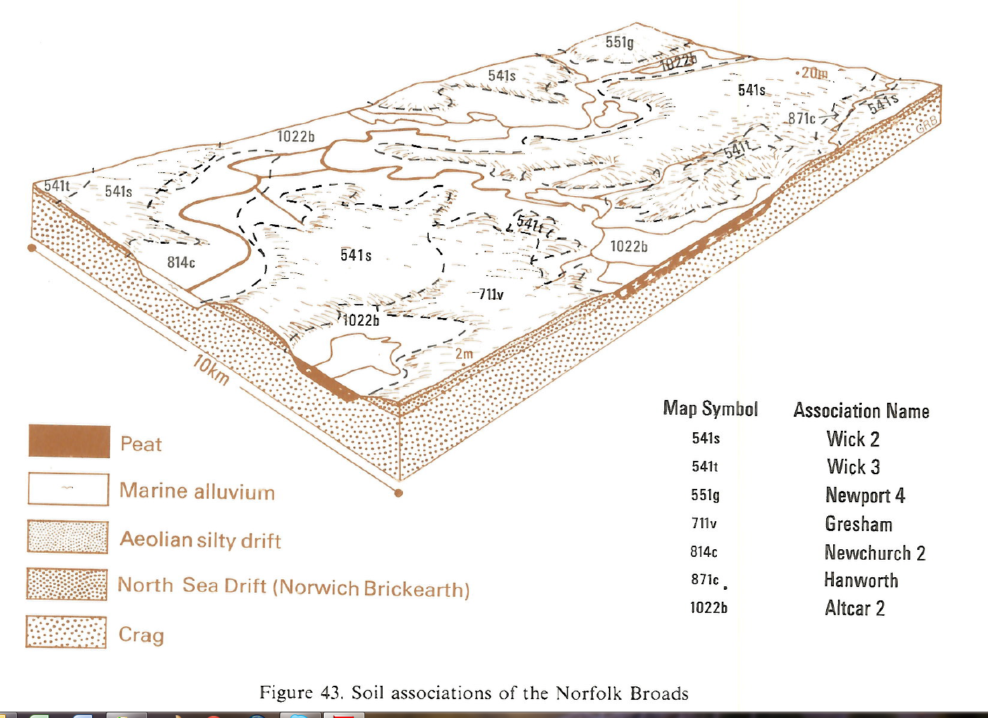
Soil Associations
1022b ALTCAR 2
Soil and site characteristics
Deep peat soils, in part very acid. Flat land. Groundwater levels often controlled by ditches and pumps but in places the soils are undrained. Risk of wind erosionGeology
Fen peatCropping and Land Use
Wetland and woodland habitats and rough grazing; cereals, sugar beet and field vegetables with groundwater control.
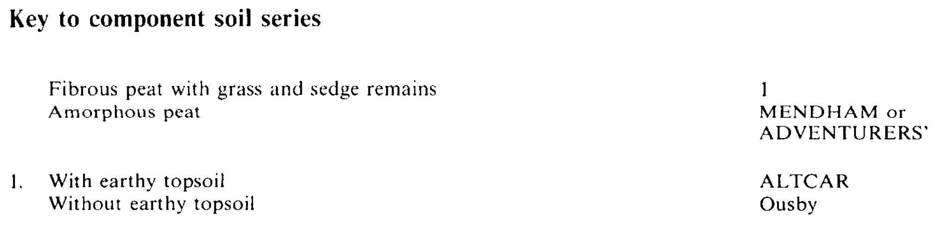
Component soil series
| Subgroup | Series name | Percentage | WRB 2006 link |
|---|---|---|---|
| 10.22 | ALTCAR | 50% | Drainic Rheic Fibric Histosols |
| 10.24 | ADVENTURERS' | 30% | Drainic Rheic Sapric Histosols |
| 10.25 | MENDHAM | 20% | Drainic Rheic Sapric Thionic Histosols |
Covers 111 km2 in England and Wales
Soilscapes Classification
| 27 |
Fen peat soils |
1022b ALTCAR 2
Detailed Description
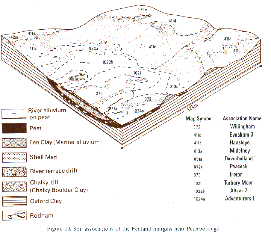
These peaty soils are most extensive on flat low-lying fenland in eastern England (Hodge et al. 1984). In Nottinghamshire they extend along the Idle valley from Hayton to Misson and are more fully described by Reeve and Thomasson (1981). The main soils are classified with Altcar series, earthy eu-fibrous peat soils, and have peaty topsoils over partly humified semi-fibrous or fibrous peat with recognizable remains of grasses and sedges. In the associated Adventurers' series , which belongs to the earthy eutro-amorphous peat soils, the profiles are humified and amorphous throughout, with very few visible plant remains. The less common Mendham series, earthy sulphuric peat soils, is also in humified peat but subsoils are extremely acid from oxidation of iron sulphides upon drainage. There is a wide variation in peat thickness, degree of peat decomposition, subsoil acidity and texture of the mineral substrate. The deepest peats, in the Middle Idle valley near Wiseton and close to the river near Misson, are usually strongly acid. Around Misson, Wiseton and Clayworth they often have thin clayey or silty alluvial topsoils and, at Misson, woody remains can be encountered at depth.
In Norfolk, where the soils are largely undrained, Altcar series occupies about half the land and Adventurers' series one third. Where the fen flanks tidal rivers there are some sedge peats giving the Ousby series, lacking an earthy topsoil. Few soils are at present sulphuric and acid but feasibility studies for major drainage improvement show that many are potentially so (Broads Authority 1981). If drainage is undertaken the economic benefits are likely to be small because of acid soil conditions. The Cambridgeshire Fens have been systematically drained since the 17th century and because of the consequent shrinkage and wastage, the land surface has been lowered from 3 or 4 m O.D. to below sea level in places. Today the process continues at a reduced rate and the peatland shrinks in extent as the underlying mineral substratum emerges. Well humified Adventurers' soils are more common in the Fens than in Norfolk and occupy almost half the land, with the other main soil, Altcar series, occupying about a third. In some Adventurers' soils the mineral substratum rises within 90 cm depth, above which there is often a thin, "drummy" horizon of acid peat that does not rewet easily after drying. The distribution of sulphuric horizons is typically patchy both within soil profiles and laterally. Mendham soils with such horizons are estimated to occupy about a fifth of the land.
Soil Water Regime
Most of the soils forming this association in Norfolk are undrained and severely waterlogged (Wetness Class V and VI). They occupy narrow strips in valleys lacking efficient arterial drainage.
In the Fens, where there is a very low rainfall and an efficient pumped drainage system, the soils are mainly well drained (Wetness Class I), but some, particularly where the peat rests on an impermeable substratum, are occasionally waterlogged (Wetness Class II). Pipe drainage is needed in larger fields to assist water table control largely achieved by ditches and arterial systems. The effectiveness of underdrainage is often impaired by the deposition of colloidal iron hydroxide (ochre) in the pipes. Peat soils store and supply to plants large quantities of water, up to the equivalent of 400 mm of rainfall. Their capacity to do so is reduced by humification following drainage and by addition of mineral material to their topsoils. Peat soils are thus non-droughty except those of Mendham series, where roots are checked by acidity and aluminium toxicity. These soils are slightly droughty for most crops and very droughty for grass, except where groundwater is maintained within rooting depth.
Cropping and Land Use
Ease of cultivation is strongly influenced by drainage. In Norfolk, where the soils are mostly undrained and commonly lie wet for long periods in winter, they have little bearing strength, and so are generally unsuitable for cultivation. On the other hand, soils in the Fens have a long autumn work period and plenty of opportunity for spring tillage. Here too the soils can be worked from time to time during drier spells in most winters. The component peat soils are naturally acid and the general practice is to lime to pH 5.8. Above this level maganese deficiency can occur. Sulphuric horizons have pH values below 4, large concentrations of soluble aluminium and are generally toxic to roots, thus reducing rooting depth, the amount of water available to plants and crop yields. Large oak, yew and pine logs (bog oaks) appear near the surface as the peatlands waste and unless removed damage farm implements and impede cultivation.
In Norfolk the association is under alder carr woodland or permanent grassland belonging to farms on adjacent higher ground. The grassland is mainly grazed by dairy cows, dairy replacements or beef store cattle and there is a risk of poaching. Some farmers attempt arable cropping. The reed and sedge fens adjacent to the tidal rivers provide the recreation and conservation areas of Broadland.
Up to half the land in the Fens is in sugar beet and potatoes with some horticultural crops such as carrots and onions. Wheat is used as a break crop but cereals do not finish well. As the peat wastes the land is increasingly used for cereals or cereals in rotation with ley grassland. Most years in spring, the fine tilth of the peat soils is susceptible to wind erosion where there is little shelter. Seed, fertilizer and up to 2cm of surface soil are blown away, dykes infilled, and seedlings damaged. Where damage is severe crops have to be resown, often when it is too late for a full yield. On some farms, shelter belts and inter-row nurse crops are planted to reduce the risk but, more usually, no special measures are taken.
1022b ALTCAR 2
Distribution Map
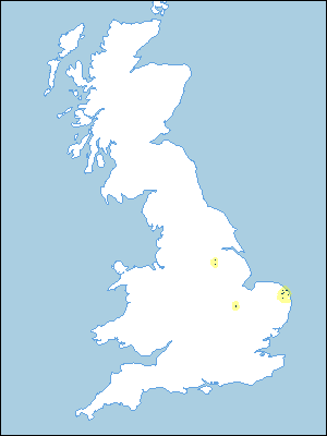 |
Note that the yellow shading represents a buffer to highlight the location of very small areas of the association.
Keys to component soil series
Eastern Region
 |
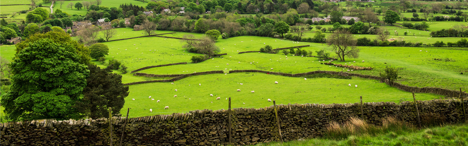
Typical Landscapes
Eastern Region
 |
Eastern Region
 |
All information Copyright, Cranfield University © 2025
Citation: To use information from this web resource in your work, please cite this as follows:
Cranfield University 2025. The Soils Guide. Available: www.landis.org.uk. Cranfield University, UK. Last accessed 06/04/2025
