Soil Associations
0421a STOW
Soil and site characteristics
Slowly permeable clayey soils, mainly on steep slopes. Some fine silty and fine loamy soils over siltstone, the latter with slowly permeable subsoils and slight seasonal waterlogging. Slowly permeable seasonally waterlogged clayey soils on less sloping ground.
Geology
Jurassic mudstone and siltstone
Cropping and Land Use
Permanent and short term grassland with dairying and stock rearing: some cereals; coniferous woodland.
Component soil series
| Subgroup | Series name | Percentage | WRB 2006 link |
|---|---|---|---|
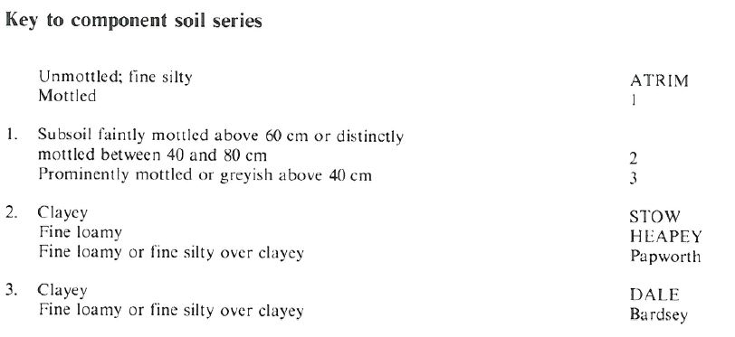
| 4.21 | STOW | 50% | Stagnic Cambisols |
| 5.41 | ATRIM | 15% | Siltic Eutric Cambisols |
| 5.42 | HEAPEY | 15% | Eutric Endostagnic Endoskeletic Cambisols |
| 7.12 | DALE | 10% | Clayic Eutric Stagnosols |
Covers 108 km2 in England and Wales
Soilscapes Classification
| 8 |
Slightly acid loamy and clayey soils with impeded drainage |
0421a STOW
Detailed Description
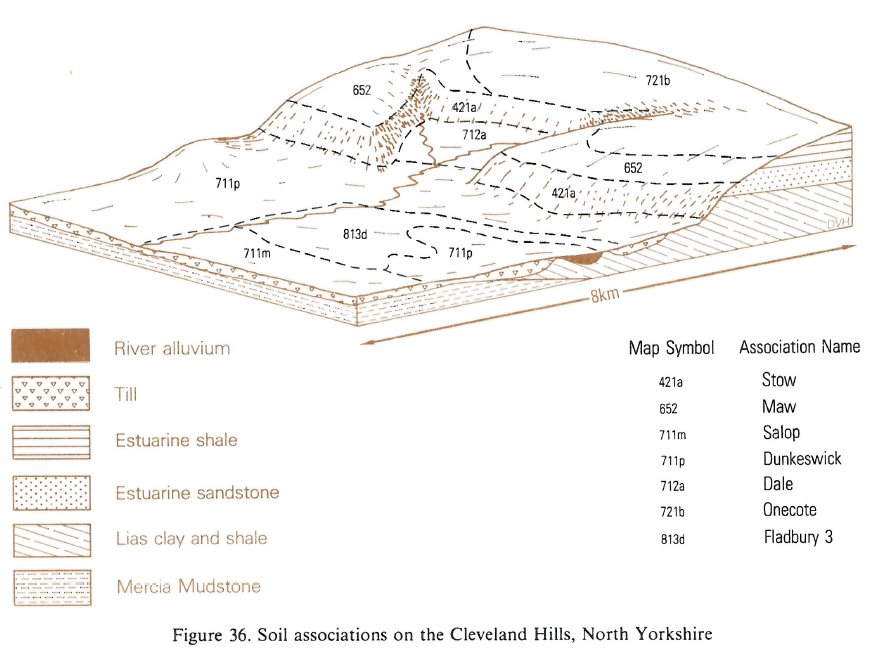
This association is composed mainly of clayey or loamy soils formed from Jurassic mudstones and siltstones. The chief soil, the Stow series, typical non-calcareous pelosols, has slowly permeable clayey subsurface horizons but, unlike the associated pelo¬stagnogley soils of the Dale series, has no gleyed subsurface horizon. Other component soils include the Atrim series, fine silty typical brown earths, and the Heapey series, fine loamy stagnogleyic brown earths. The association occurs on the steep sides of valleys incised into the North York Moors and on the Cleveland Hills escarpment at elevations ranging from 120 to 380 m O.D.
The Atrim series is found on valley-side benches where the underlying siltstone is relatively permeable. The Stow and Heapey series are on adjacent steeper slopes underlain by mudstone. The Dale, Bardsey and Papworth series, which were described as Long Load, Rowsham and Podimore series respectively, occur mainly on gentler slopes where subsurface horizons are clayey or, locally, in landslipped areas. The Newtondale series occupies steep upper slopes or crests of valley sides, and Wick, formerly Faceby series, occurs where deep Head has accumulated. The Onecote series is occasionally found near spring lines.
Soil Water Regime
The Stow series is seasonally waterlogged (Wetness Class III), having a clayey, water retentive topsoil and being slowly permeable. Surplus winter rainwater moves laterally at depths less than 50 cm on slopes steeper than 8 degrees; on gentler slopes run-off is less. The Atrim series is more permeable and better drained (Wetness Class I). Estimates of profile available soil water and crop-adjusted soil moisture deficit indicate that grass is slightly affected and cereal crops are not affected by drought in average years.
Cropping and Land Use
The steepness of the land largely precludes cereal production but some barley is grown on gentler slopes on lower ground, especially on Atrim soils. Careful management is always required, however, and timely cultivations are essential if smearing and compaction of the soil are to be avoided. Consideration of the effects of soil and climate suggests that spring cultivation for arable crops is usually advisable only on the Atrim series, while on the wetter Heapey and Stow series about one autumn in four will have poor conditions for cultivations. These are traditionally grassland soils and potential yields are moderately large, and only slightly affected by the short growing season or droughtiness. Stow soils poach and rut easily however, and can be grazed by cattle in the summer only. They do not readily absorb slurry. Re-seeding is best done in summer, when the clayey topsoils are less likely to suffer structural damage through being worked when moist and plastic. The land is lightly stocked and little used in the winter. The steepest slopes cannot be safely or efficiently managed and are often left as rough grazing, partly covered by scrub woodland or bracken. Atrim soils occur on less steep slopes and, in addition, are less liable to poaching.
In the Cleveland Hills the association is under Scots pine and Japanese larch. Steep slopes are the main limitation to tree planting and cable cranes are usually needed for extraction. Weed growth is heavy. The soils are fertile enough for some hardwoods, and are capable of producing good crops of Sitka or Norway spruce. Most of the association is within the North York Moors National Park, and is crossed by the Cleveland Way and other long-distance footpaths.
0421a STOW
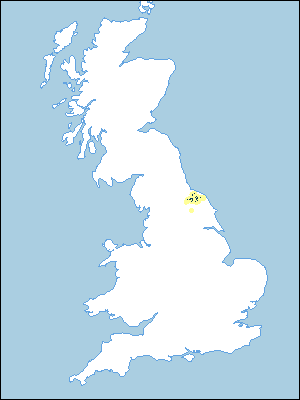
Distribution Map
 |
Note that the yellow shading represents a buffer to highlight the location of very small areas of the association.
Keys to component soil series
Northern Region
 |
Typical Landscapes
Northern Region
 |
All information Copyright, Cranfield University © 2025
Citation: To use information from this web resource in your work, please cite this as follows:
Cranfield University 2025. The Soils Guide. Available: www.landis.org.uk. Cranfield University, UK. Last accessed 04/04/2025
