Soil Associations
0714a DUNKESWELL
Soil and site characteristics
Slowly permeable seasonally waterlogged fine silty over clayey soils some with a humose surface horizon. Some deep fine silty over clayey soils with slowly permeable subsoils and slight seasonal waterlogging.Geology
Plateau driftCropping and Land Use
Dairying on short term and permanent grassland cereals; some coniferous woodland and wet heath.
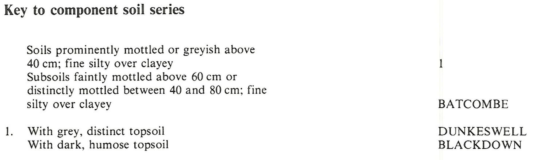
Component soil series
| Subgroup | Series name | Percentage | WRB 2006 link |
|---|---|---|---|
| 7.14 | DUNKESWELL | 60% | Chromic Alic Planosols |
| 7.23 | BLACKDOWN | 25% | Chromic Dystric Histic Stagnosols |
| 5.82 | BATCOMBE | 10% | Profundic Chromic Endostagnic Luvisols |
Covers 57 km2 in England and Wales
Soilscapes Classification
| 17 |
Slowly permeable seasonally wet acid loamy and clayey soils |
0714a DUNKESWELL
Detailed Description
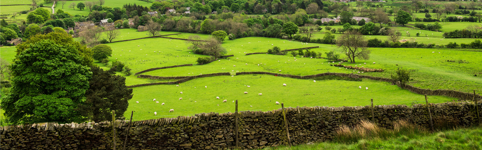
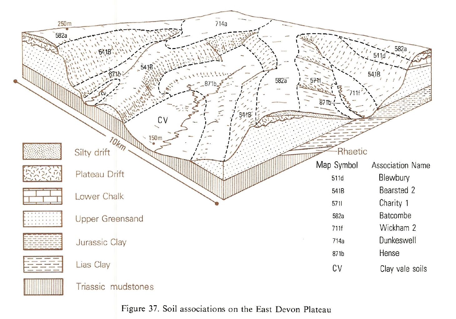
Surface-water gley soils of the Dunkeswell series and Blackdown series characterize this map unit, which is confined to east Devon and south-west Somerset. They are developed in aeolian silty drift over clayey Plateau Drift which in turn caps the Upper Greensand of the East Devon Plateau and the adjacent Blackdown Hills. The land ranges from 160 m O.D. near Lyme Regis to 315 m O.D. on the Blackdown Hills, where it occupies level or gently sloping hilltops. The soils have mottled, silty, slightly stony upper horizons in which wetness is caused by the slowly permeable mottled flinty clay subsoil. The paleo-argillic stagnogley soils of the Dunkeswell series differ from the Blackdown series only in the absence of a peaty surface horizon, which puts the latter soils in the paleo-argillic stagnohumic gley subgroup. The Dunkeswell series is the most extensive component, Blackdown series covering about a quarter of the area and the drier Batcombe soils occurring locally. Brief profile descriptions of the main soil series follow: The surface horizons of Dunkeswell soils vary considerably, about half of them having little or no gleying as evidence of seasonal wetness. The Blackdown series is found with peaty topsoils under wet heathland at Gittisham Hill, Culmstock Beacon and Trinity Hill, Uplyme. Elsewhere, reclamation and cultivation following the enclosures of the last century has given the humose topsoils found on present farmland. Batcombe series provides drier land within the association. On the East Devon Plateau and Blackdown Hills, Dunkeswell association is intermixed with the Batcombe association, the Dunkeswell soils giving place to Batcombe series as slopes steepen at the plateau edge. The parent material of both associations, thin silty drift over Plateau Drift, extends eastward across southern England to the Downs of Kent and the Chilterns. However the sequence of increasing soil wetness, from Batcombe through Dunkeswell to Blackdown series, is seen only in east Devon and south Somerset in wetter climatic conditions.
Soil Water Regime
Slowly permeable layers below about 50 cm depth cause wetness in the Dunkeswell and Blackdown series. In the latter this is exacerbated by the water-retentive peaty or humose surface horizon. Where undrained, both series are seasonally waterlogged (Wetness Class IV) but are improved with drainage (Wetness Class III). Damage caused by ill-timed cultivations or by grazing under wet conditions in turn increases surface wetness.
Cropping and Land Use
Leys and permanent grassland predominate although some cereals are grown. On the Blackdown series there are coniferous plantations and remnants of once extensive heathland. Grassland yields are rarely limited by droughtiness as the soils are often at field capacity for parts of the growing season. Even where the soils are effectively drained, surface horizons are wet enough for long periods in spring and autumn for the sward to be damaged by grazing stock and by machinery, particularly on Blackdown series where topsoils have weak bearing strength. Soil and climate combine to make these soils unsuitable for continuous arable cropping. Near to the coast in a normal autumn there is scope for landwork under good ground conditions, but there is no opportunity in wetter seasons. Even when cultivation is carried out under suitable weather and ground conditions the large silt content often causes slaking and loss of soil structure under heavy rainfall, particularly when there is incomplete crop cover. Slaking reduces soil porosity and so impedes soil water movement.
The limited scope for agriculture on Blackdown series has encouraged afforestation. These wet soils with their dense, clayey subsoils preclude the more demanding trees, so Sitka spruce is the most appropriate species. In exposed places, windthrow of shallow rooted mature trees is a risk. Heathlands, particularly those near to the coast, add to the charm of the Wessex landscape and have value as commons and open spaces, or as refuges for wildlife. Several are adjacent to similarly attractive tracts of woodland and semi-natural vegetation on Bearsted and Hense associations along the Greensand scarp and springline.
0714a DUNKESWELL
Distribution Map
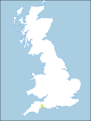 |
Note that the yellow shading represents a buffer to highlight the location of very small areas of the association.
Keys to component soil series
South Western Region
 |
Typical Landscapes
South Western Region
 |
All information Copyright, Cranfield University © 2025
Citation: To use information from this web resource in your work, please cite this as follows:
Cranfield University 2025. The Soils Guide. Available: www.landis.org.uk. Cranfield University, UK. Last accessed 06/04/2025
