
Soil Associations
0714d ESSENDON
Soil and site characteristics
Slowly permeable seasonally waterlogged coarse loamy over clayey soils. Associated with similar fine loamy over clayey and fine silty over clayey soils.
Geology
Plateau and river terrace drift
Cropping and Land Use
Dairying; winter cereals in Hertfordshire and Essex; lowland heath and woodland habitats, coniferous woodland; recreation.
Component soil series
| Subgroup | Series name | Percentage | WRB 2006 link |
|---|---|---|---|
| 7.14 | ESSENDON | 35% | Chromic Alic Planosols |
| 7.14 | OAK | 25% | Chromic Luvic Stagnosols |
| 7.11 | WICKHAM | 20% | Eutric Luvic Planosols |
| 5.82 | BERKHAMSTED | 10% | Abruptic Chromic Endostagnic Luvisols |
| 5.82 | HORNBEAM | 10% | Profundic Chromic Endostagnic Luvisols |
Covers 222 km2 in England and Wales
Soilscapes Classification
| 17 |
Slowly permeable seasonally wet acid loamy and clayey soils |
0714d ESSENDON
Detailed Description
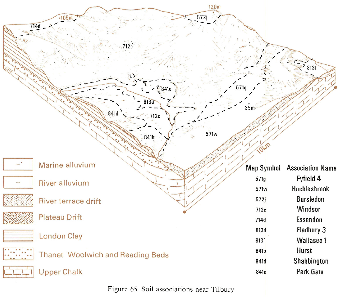
Seasonally waterlogged, flinty loamy over clayey soils predominate in this association. They are developed in gravelly Plateau and river terrace drifts where they overlie slowly permeable Jurassic, Cretaceous and Tertiary strata. The drifts, originally deposited before the last glaciation, have been reworked under periglacial conditions in one or more cold periods so the junction between the drift and the underlying solid deposits is often convoluted. Most of the soils are red mottled from weathering in warmer periods during the Pleistocene period. The soils mainly cap low hills and ridges and adjacent gently sloping land in the Thames valley.
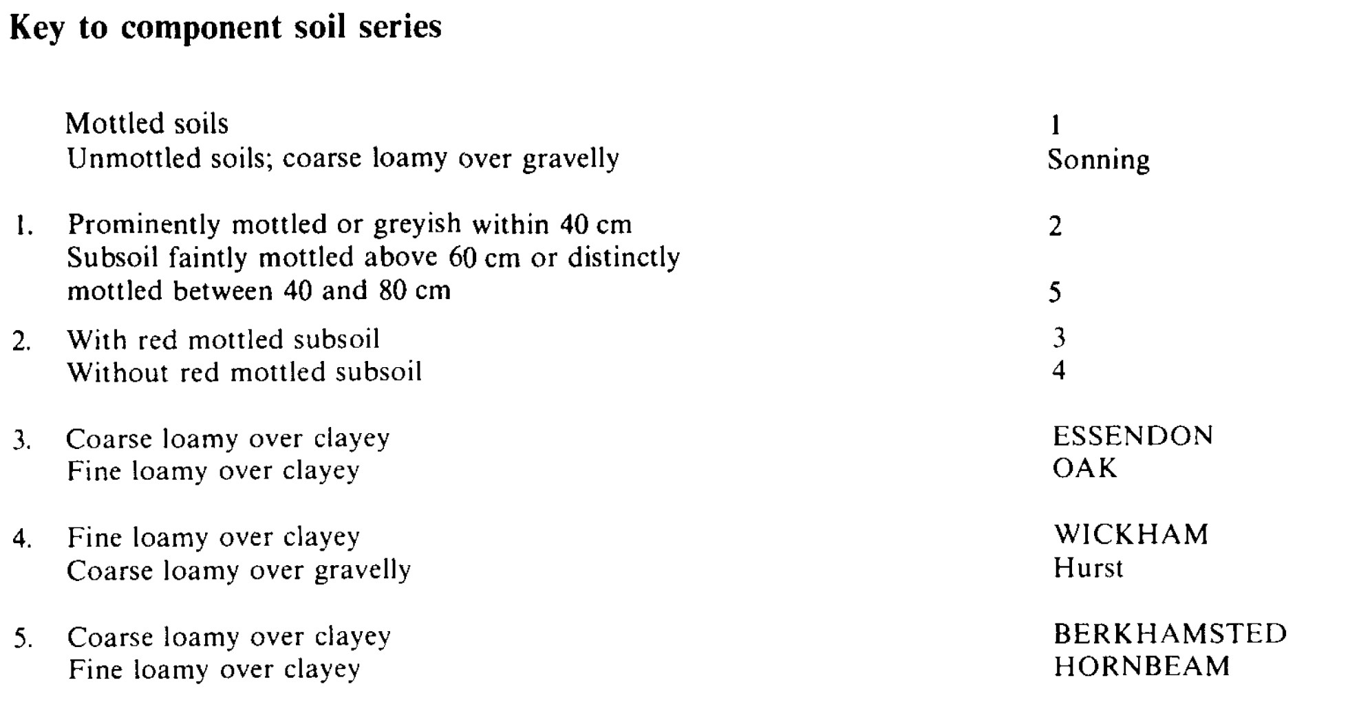
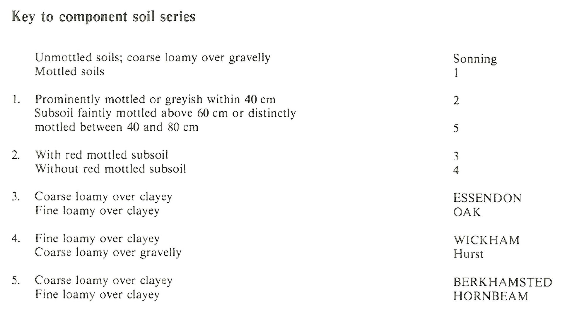
The main soils belong to the Essendon and Oak series, flinty coarse or fine loamy over clayey paleo-argillic stagnogley soils with slowly permeable subsoils. Wickham soils are fine loamy over clayey typical stagnogley soils that occur where the drift thins over a clay substrate, and Berkhamsted and Hornbeam soils are stagnogleyic paleo-argillic brown earths with red mottled clay subsoils. Essendon and Oak soils are dominant on level and gently sloping surfaces with Berkhamsted and Hornbeam soils occurring sporadically. Wickham soils are found on the upper slopes of valleys.
The association is mapped above 100 m O.D. on cappings of Pebbly Clay Drift on level and gently sloping plateaux and ridges dissected by valleys cut through to the underlying London Clay. It is most extensive between Hatfield, Barnet and Hoddesdon in south Hertfordshire and around Brentwood and there are small patches near Bushey Heath, in north London.
The component soils are varied in their distribution. In Hertfordshire, Essendon and Oak series are co-dominant with the less frequently waterlogged Berkhamsted and Hornbeam soils locally. Wickham series is common where Pebbly Clay Drift thins downslope. On some upper valley sides gravelly Hurst soils are developed in Head. Essendon soils predominate in Essex where many soils are moderately or very stony in upper horizons. Berkhamsted soils or sandy gravelly St Albans soils (Eldridge 1980) also occur with Haldon soils in some woodlands. Where the drift thins and coils are formed in Bagshot Beds and Claygate Beds, Bursledon, Curdridge and Windsor soils are included.
The largest areas are on the northern outskirts of Slough at the foot of the Chiltern dipslope, where the drift covers slowly permeable Reading Beds and London Clay. Here many soils have very stony or gravelly upper layers. Land near Iver Heath includes significant amounts of Hurst soils with red mottles in the subsoil. There are also small patches of Sonning soils on higher ground and silty over gravelly Rowton soils in thin silty drift on level ground.
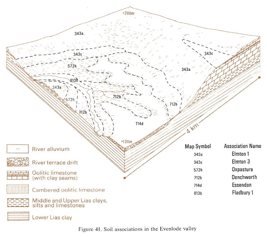
In Oxfordshire, on high ground where the drift covers Oxford Clay, or on lower ground where gravelly drift caps Lower Lias clay between the Evenlode and its tributary streams, Oak soils are dominant with Hornbeam series a common associate. Essendon soils are locally frequent. Berkhamsted, Hornbeam and Oak soils are equally common where the drift covers London Clay north-east of Guildford. Near Farnham, Southampton soils are found on narrow ridge crests. Near Upchurch in north Kent very stony Essendon and Oak soils predominate, with subordinate very stony, well drained sandy gravelly St Albans soils on higher ground, and sporadic Wickham soils where the drift thins.
Soil Water Regime
Essendon, Oak and Wickham soils have slowly permeable clayey subsoils and are seasonally waterlogged (Wetness Class III or IV) when undrained. Excess winter rain is mainly disposed of laterally at shallow depth over the clayey subsoil and as surface flow. Surface waterlogging in winter can be prolonged in wet years. Hornbeam and Berkhamsted soils are occasionally waterlogged (Wetness Class II or III) when undrained. Where Essendon, Oak and Wickham soils have been improved by drainage measures, they are occasionally or seasonally waterlogged (Wetness Class II or III). The principal soils have good reserves of available water, and cereal and oilseed rape crops suffer slightly from drought. Yields of grass are reduced by water stress in most years.
Cropping and Land Use
There are plenty of opportunities for autumn landwork in most years but few suitable days for cultivation in spring, so winter cereals are the favoured crops. Some land is under grass for dairy herds or in small paddocks for horses.
Stoniness hinders precision drilling and reduces available water so arable cropping is not commonly practised except in Oxfordshire. Where cereals are grown they are autumn-sown because there is little opportunity to work the soils in spring in most years. Most land is under grass but there is an appreciable risk of poaching and cattle damage swards if they are grazed too early in spring.
Much land, which until relatively recently was heathland, is now secondary woodland. For example, Burnham Beeches was once grazed heathland that has been subsequently invaded by birch and then by oak and in some places by beech. Berkhamsted and Sonning soils now support birch-oak woodland and open habitats with bracken (Pteridium aquilinum) or ling (Calluna vulgaris) are restricted in extent. Small areas of wet heathland are present, for example on Stoke Common, and have purple moor-grass (Molinia caerulea) and cross-leaved heath (Erica tetralix). Littleworth Common also has birch-oak woodland with alder buckthorn (Frangula alnus), wavy hair-grass (Deschampsiaflexuosa), common bent-grass (Agrostis capillaris), bracken and bramble (Rubus spp.). Heathland is still present on Stoke Common but birch and Scots pine are spreading into the open areas.
0714d ESSENDON
Distribution Map
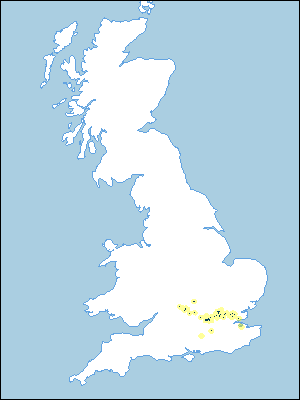 |
Note that the yellow shading represents a buffer to highlight the location of very small areas of the association.
Keys to component soil series
Eastern Region
 |
South Eastern Region
 |
Typical Landscapes
Eastern Region
 |
South Eastern Region
 |
All information Copyright, Cranfield University © 2025
Citation: To use information from this web resource in your work, please cite this as follows:
Cranfield University 2025. The Soils Guide. Available: www.landis.org.uk. Cranfield University, UK. Last accessed 04/04/2025
